


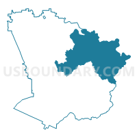
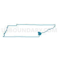
14 Toqua Community Center Voting District, Monroe County, Tennessee
About
Outline

Summary
| Unique Area Identifier | 669258 |
| Name | 14 Toqua Community Center Voting District |
| County | Monroe County |
| State | Tennessee |
| Area (square miles) | 140.04 |
| Land Area (square miles) | 130.42 |
| Water Area (square miles) | 9.62 |
| % of Land Area | 93.13 |
| % of Water Area | 6.87 |
| Latitude of the Internal Point | 35.48727450 |
| Longtitude of the Internal Point | -84.10380500 |
Maps

Graphs
Select a template below for downloading or customizing gragh for 14 Toqua Community Center Voting District, Monroe County, Tennessee


Neighbors
Neighoring Voting District (by Name) Neighboring Voting District on the Map
- 04 Vonore Elementary School Voting District, Monroe County, TN
- 07 Madisonville Primary School Voting District, Monroe County, TN
- 11 Tellico Community Center Voting District, Monroe County, TN
- Lanier Voting District, Blount County, TN
- Voting District TAPO, Graham County, NC
Top 10 Neighboring County Subdivision (by Population) Neighboring County Subdivision on the Map
- District 2, Monroe County, TN (16,598)
- District 3, Monroe County, TN (13,442)
- District 7, Blount County, TN (13,268)
- Yellow Creek township, Graham County, NC (642)
Top 10 Neighboring Unified School District (by Population) Neighboring Unified School District on the Map
- Blount County School District, TN (87,224)
- Monroe County School District, TN (32,521)
- Graham County Schools, NC (8,861)
Top 10 Neighboring State Legislative District Lower Chamber (by Population) Neighboring State Legislative District Lower Chamber on the Map
- State House District 21, TN (73,052)
- State House District 120, NC (72,565)
- State House District 20, TN (69,827)
- State House District 23, TN (64,022)
Top 10 Neighboring State Legislative District Upper Chamber (by Population) Neighboring State Legislative District Upper Chamber on the Map
- State Senate District 8, TN (212,899)
- State Senate District 5, TN (207,003)
- State Senate District 50, NC (175,858)
Top 10 Neighboring 111th Congressional District (by Population) Neighboring 111th Congressional District on the Map
Top 10 Neighboring Census Tract (by Population) Neighboring Census Tract on the Map
- Census Tract 9254, Monroe County, TN (8,854)
- Census Tract 9250, Monroe County, TN (7,528)
- Census Tract 115.02, Blount County, TN (4,065)
- Census Tract 9255.01, Monroe County, TN (3,046)
- Census Tract 9201, Graham County, NC (2,197)
- Census Tract 115.01, Blount County, TN (1,738)
Top 10 Neighboring 5-Digit ZIP Code Tabulation Area (by Population) Neighboring 5-Digit ZIP Code Tabulation Area on the Map
- 37803, TN (31,668)
- 37801, TN (25,124)
- 37354, TN (16,483)
- 28771, NC (8,558)
- 37385, TN (8,131)
- 37885, TN (5,067)
- 37878, TN (514)